


Természetjáró, a túratervező
Természetjáró, a túratervező ၏ ရွင္းလင္းခ်က္
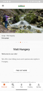
ဟန်ဂေရီ၏ အွန်လိုင်းခရီးသွားဧည့်လမ်းညွှန်သည် တောင်တက်သမားများ၊ စက်ဘီးသမားများ၊ လမ်းအပြေးသမားများ၊ ရော့ခ်တောင်တက်သူများနှင့် ရေအားကစားကိုနှစ်သက်သူများအတွက် အထူးထုတ်လုပ်ထားသည့် ခရီးစဉ်အစီအစဉ်တစ်ခုအပြင် အကြံပြုထားသည့် ခရီးစဉ်ပေါင်းရာနှင့်ချီနှင့် ထောင်ပေါင်းများစွာသော မြင်ကွင်းများပါရှိသော၊ အားလုံးသည် အသေးစိတ်ဖော်ပြချက်များနှင့် ဓာတ်ပုံများစွာပါရှိသည် အပြန်အလှန်ဆက်သွယ်နိုင်သော မြေပုံပေါ်တွင် သက်တောင့်သက်သာဖြင့် ကြည့်ရှုနိုင်သည်။ တိုးချဲ့လုပ်ဆောင်နိုင်စွမ်းအတွက် စာရင်းသွင်းမှုရွေးချယ်မှုဖြင့် အခမဲ့ရနိုင်သည်။
အင်္ဂါရပ်များ
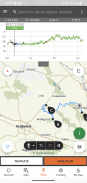
• အမျိုးမျိုးသောအပြန်အလှန်အကျိုးသက်ရောက်မှု၊ ချဲ့ထွင်နိုင်သော၊ ပုံသဏ္ဍာန်ပြုလုပ်ထားသော၊ ကမ္ဘာတစ်ဝှမ်းရှိ တောင်တက်မြေပုံများ သည် သင်၏လက်ရှိအနေအထားကိုပြသသော အမှတ်အသားရှိသောလမ်းကြောင်းများ
• မြေပုံပေါ်တွင် သင့်ကိုယ်ပိုင် ခရီးစဉ်ကို စီစဉ်ရန်နှင့် အရှည်၊ ကြာချိန်နှင့် အမြင့်ပရိုဖိုင်ကို ချက်ချင်းရယူရန် အဆင်ပြေသောနည်းလမ်း
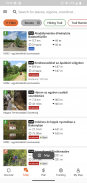
• လက်တွေ့ကျသောဒေတာ၊ အနီးနားရှိအကောင်းဆုံးမြင်ကွင်းများ၊ သဘာဝနှင့်ယဉ်ကျေးမှုနောက်ခံ၊ အရည်အသွေးကောင်းမွန်သောဓာတ်ပုံများနှင့် အချက်အလက်များပါရှိသော တောင်တက်သမားများ၊ စက်ဘီးစီးသူများ၊ လမ်းအပြေးသမားများနှင့် ကနူးလှေများအတွက် အကြံပြုထားသော ခရီးစဉ်တစ်ထောင်ကျော်၊
• မျှော်စင်များ၊ သဘာဝမြင်ကွင်းကျယ်များ၊ သစ်တောရထားများ၊ ခံတပ်များနှင့် ပြတိုက်များအပါအဝင် ဟန်ဂေရီရှိ ထောင်ပေါင်းများစွာသော အကြံပြုထားသော ရှုခင်းများ၊ အသေးစိတ်ဖော်ပြချက်၊ အရည်အသွေးကောင်းမွန်သော ဓာတ်ပုံများနှင့် ထိုနေရာသို့ ဘယ်လိုသွားရမည်ကို အချက်အလက်များ အပါအဝင်
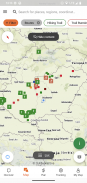
• သတ်မှတ်ထားသောလမ်းများအနီးရှိ တဲများ၊ ခရီးသွားဟိုတယ်များနှင့် တိုက်ခန်းများအပါအဝင် ရာနှင့်ချီသောနေရာထိုင်ခင်းများ
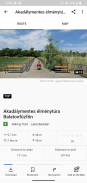
• မြေပုံမြင်ကွင်းဖြင့် အသုံးဝင်သောစုဆောင်းမှုများ- Balaton ရေကန်ဝန်းကျင်ရှိ ကမ်းခြေများ၊ ရေခဲပြင်စကိတ်ကွင်းများ၊ ရုက္ခဗေဒဥယျာဉ်များ၊ အကောင်းဆုံးလမ်းပြေးလမ်းကြောင်းများ၊ ကျောက်တောင်တက်နေရာများ၊ မသန်စွမ်းသူများနေထိုင်သည့် ခရီးစဉ်များ စသည်တို့။
• သတိပေးချက်များ၊ သတိပေးချက်များနှင့် ပိတ်ခြင်း
• အော့ဖ်လိုင်းအသုံးပြုရန်အတွက် မြေပုံကဏ္ဍများ၊ ခရီးစဉ်များနှင့် မြင်ကွင်းများကို ဒေါင်းလုဒ်လုပ်ပါ
• တိုက်ရိုက်အမြင့်ပရိုဖိုင်နှင့် အသံညွှန်ကြားချက်များဖြင့် လမ်းကြောင်းတစ်လျှောက်တွင် ပျံသန်းနေသော လမ်းကြောင်းပြ
• သင့်လမ်းကြောင်းကို မှတ်တမ်းတင်ပါ
• BuddyBeacon- သင်၏ positon ကို သူငယ်ချင်းများနှင့် တိုက်ရိုက်မျှဝေပါ။
• ပြီးပြည့်စုံသော Hungarian Blue Tour၊ တရားဝင်အပိုင်းများနှင့် လမ်းကြောင်းများ၊ POIs နှင့် တည်းခိုစရာများ
• အက်ပ်ကိုအသုံးပြုနေသည့် ကွန်ပျူတာနှင့် မိုဘိုင်းစက်ပစ္စည်းများကြားတွင် သင့်အကြောင်းအရာအားလုံးကို ထပ်တူပြုပါ။
• ဒေသဆိုင်ရာ မိုးလေဝသခန့်မှန်းချက် ကို စစ်ဆေးပါ။
• 3D-ပျံသန်းမှု- ခရီးစဉ်အတွက် ငှက်မျက်လုံးမြင်ကွင်း
• သင့်လက်ရှိအနေအထားဖြင့် peak finder(Skyline) နှင့် compass ကဲ့သို့သော အသုံးဝင်သောကိရိယာများ
• အသိုင်းအဝိုင်းဝန်ဆောင်မှုများ- သင့်သူငယ်ချင်းများနှင့် အကြောင်းအရာများကို အဆင့်သတ်မှတ်ပြီး မျှဝေပါ။
Google မှ WEAR OS ပါသော စမတ်နာရီများ
သင့်စမတ်နာရီကို တစ်ချက်ကြည့်လိုက်ခြင်းဖြင့် သင်သည် မြေပုံပေါ်တွင် သင့် GPS တည်နေရာအကြောင်း အချက်အလက်ကို ရရှိမည်ဖြစ်သည်။ သင်သည် တေးသွားများကို မှတ်တမ်းတင်နိုင်သည်၊ ခြေရာခံခြင်းဒေတာကို ရယူနိုင်ပြီး လမ်းကြောင်းများတစ်လျှောက် သွားလာနိုင်သည်။ အနီးနားရှိ လမ်းကြောင်းများကို အလွယ်တကူဝင်ရောက်နိုင်ရန် အက်ပ်အကွက်ကို အသုံးပြုပါ။
Pro အဖွဲ့ဝင်များအတွက် သီးသန့်
ဘယ်နေရာမဆိုသွားပါ - Outdooractive Pro သည် မိုဘိုင်းနှင့် ဒေတာအချက်ပြမှုများမပါဘဲ အော့ဖ်လိုင်းအလုပ်လုပ်သည်။ အကန့်အသတ်မဲ့စာရင်းများကိုလည်း ဖန်တီးနိုင်ပြီး အက်ပ်သည် ကြော်ငြာမဲ့ဖြစ်သည်။ ထို့အပြင်၊ လှုပ်ရှားမှုလမ်းကြောင်းကွန်ရက် 30 ကျော်နှင့် အောက်ဖော်ပြပါ ဝန်ဆောင်မှုပေးသူများထံမှ တရားဝင် မြေမျက်နှာသွင်ပြင်မြေပုံများပါရှိသော ထူးခြားသည့် အပြင်ပန်းလှုပ်ရှားမှုမြေပုံကို သင်ကြည့်ရှုနိုင်သည်-
Great Britain Ordnance Survey၊ Landranger၊ Explorer
နယူးဇီလန်မြေအချက်အလက်
Utah USGS
ဂျာမနီ BKG
Austria BEV
ဆွစ်ဇာလန် swisstopo
ပြင်သစ် IGN
စပိန် CNIG
အီတလီ
နယ်သာလန် PDOK
နော်ဝေး Kartverket
ဒိန်းမတ် Kortforsyningen
ဆွီဒင်နိုင်ငံ Lantmäteriet
ဖင်လန်အမျိုးသားမြေတိုင်း၊
ဂျပန် GSI
ကမ္ဘာလုံးဆိုင်ရာမြေပုံ
Pro+ အဖွဲ့ဝင်များအတွက် သီးသန့်
Pro+ တွင် Alpine Associations မှ တရားဝင်မြေပုံများအပြင် KOMPASS မှ ပရီမီယံမြေပုံများပါရှိသည်။
မေးခွန်းများ သို့မဟုတ် အကြံပြုချက်များရှိပါက၊ ကျေးဇူးပြု၍
သွားရောက်ကြည့်ရှုပါ။
https://www.termeszetjaro.hu/hu/p/gyakran-ismetelt-kerdesek/41050512 /
ကျွန်ုပ်တို့၏ ဒက်စတော့ဗားရှင်း-
https://www.termeszetjaro.hu/
Facebook တွင် ကျွန်ုပ်တို့ကို လိုက်နာပါ-
https://www.facebook.com/Termeszetjaro.hu/
ကျွန်ုပ်တို့ကို ဆက်သွယ်ပါ-
termeszetjaro@termeszetjaro.hu
TEKA ကတ်အကြောင်း နောက်ထပ်အကြောင်းအရာများ-
http://www.termeszetjarokartya.hu/
Természetjáró, a túratervező - APK သတင္းအခ်က္အလက္
APK ဗားရွင္း: 3.20.3package: com.outdooractive.mtszTermészetjáró, a túratervező ၏ ေနာက္ဆုံးဗားရွင္း
အျခား ဗားရွင္းမ်ား


က႑တူအက္ပ္မ်ား

သင္ႏွစ္သက္ႏိုင္သည္မ်ားမွာ...


